
[Editor's Note: Abdulmalik Ajibade and Piergiuseppe Fiore are members of the TWA Editorial Board and authors of previous TWA articles.]
The introduction of artificial intelligence (AI) in exploration brought tangible modifications in common workflows, rather than in result delivery. A fundamental transformation is evolving in how exploration teams interact with data, generate insights, and support decision-making under uncertainty.
For decades, exploration activities have relied on the integration of large volumes of heterogeneous data. Even though advanced software platforms have significantly improved data processing capabilities, the interpretation and integration of information have remained largely dependent on expert-driven workflows. The increasing availability of high-quality digital data sets, combined with advances in computing power and machine-learning algorithms, is now enabling a new paradigm in which AI acts as an intelligent layer across the exploration value chain.
Rather than replacing established geological and geophysical methodologies, AI enhances them by accelerating repetitive tasks, identifying complex patterns, and supporting the evaluation of multiple scenarios within compressed timeframes. This capability is particularly valuable in modern exploration environments, where decision cycles are becoming shorter and the volume of available information continues to grow exponentially. AI also fosters greater collaboration across multidisciplinary teams by facilitating the integration of geological, geophysical, petrophysical, and engineering data within common analytical environments. As a result, organizations can move from sequential workflows toward more integrated and iterative decision-making processes.
Data Quality and Human Expertise
AI's effectiveness depends entirely on the quality of the underlying data. Incomplete data sets, inconsistent labeling, acquisition biases, or historical data gaps can significantly affect model performance and reliability. Consequently, successful AI adoption requires strong data governance frameworks, standardized workflows, and continuous validation procedures. In many cases, the greatest challenge is the preparation and management of data sets capable of supporting meaningful predictions.
Equally important is the continued role of human expertise. Exploration remains an inherently uncertain discipline characterized by incomplete information and geological complexity. AI models can generate recommendations, identify anomalies, and provide probabilistic assessments, but they cannot fully replace the experience and domain knowledge of geoscientists and engineers. Human interpretation remains essential for evaluating model outputs and contextualizing results within broader technical and business objectives.
This evolving landscape is also influencing professional competencies across the industry. Future exploration teams are expected to combine traditional subsurface expertise with increasing levels of data literacy and digital skills. In this context, AI should be viewed as a decision-support capability that enhances analytical efficiency.
Outlook and Industry Impact
The continued evolution of AI technologies is expected to further strengthen their role in exploration activities. Advances in foundation models, multimodal learning, and high-performance computing are likely to enable deeper integration of geological, geophysical, and engineering data sets, creating more-comprehensive subsurface models.
As these capabilities mature, AI may contribute to reducing uncertainty, improving consistency in technical evaluations, and accelerating the identification of exploration opportunities. However, the ultimate success of these technologies will depend on an organization's ability to combine advanced analytical tools with strong domain expertise, effective data management practices, and a clear understanding of operational objectives.
The significance of AI in oil and gas exploration should not be measured solely by its performance in specific applications. Its broader value lies in its potential to reshape how information is processed, how knowledge is generated, and how decisions are made across increasingly complex exploration environments.
Why Exploration Is a Natural Fit for AI
Exploration has always been a data-rich, uncertain business. Seismic surveys, well logs, geological maps, core measurements, drilling records, and production histories describe the subsurface from different angles, but the volume and heterogeneity of these data sets often exceed what can be interpreted efficiently through manual workflows alone.
That challenge makes exploration a natural fit for AI. Modern machine-learning and deep-learning methods are well suited to pattern recognition, data integration, anomaly detection, and probabilistic ranking, especially when similar tasks must be repeated across large basins or extensive 3D seismic volumes. Used properly, AI does not replace geological reasoning; it compresses the time needed to move from raw data to testable subsurface hypotheses.
Seismic Interpretation
Among all exploration workflows, seismic interpretation is where AI has gained the most technical momentum. A recent technical survey in Geophysics notes that deep neural networks are being applied across exploration seismology for preprocessing tasks such as denoising, interpolation, first-break picking, velocity picking, and migration support, as well as for interpretation tasks including structural and geologic interpretation and prediction of subsurface properties.
This is important because seismic interpretation sits upstream of many other decisions. If a model can improve image conditioning, detect faults more consistently, track horizons faster, and classify seismic facies with fewer manual passes, then prospect generation and reservoir screening become stronger downstream. In practical terms, AI acts as a force multiplier: it pre-screens the data, highlights patterns, and lets interpreters spend more time validating geologic meaning instead of tracing every feature by hand.
How It Works
A typical AI-assisted seismic workflow (Fig. 1) starts with conditioned seismic volumes and, where available, seismic-to-well ties and interpreter-provided labels such as known faults, horizons, salt boundaries, channels, or facies intervals. From there, the system extracts seismic attributes and spatial patterns, then trains models such as convolutional neural networks or other deep-learning architectures to recognize similar features throughout the full seismic cube.
Once trained, the model scans large 2D or 3D data sets and produces fault probability volumes, horizon picks, facies classes, geobody outlines, or property predictions that interpreters can review and refine. The loop is iterative: human corrections become new labels, the model is retrained, and the interpretation improves as more examples are added.

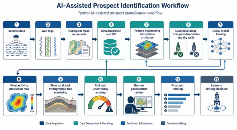
Prospect Identification and Ranking
Once seismic and geological signals are organized, AI can help identify and rank prospects by combining multiple evidence layers into a single probability-driven view of the subsurface. Rather than looking only for a structural closure or amplitude anomaly, exploration teams can train models to recognize multi-attribute signatures associated with known discoveries, dry holes, analog fields, and specific depositional settings.
This changes the economics of screening. Instead of manually maturing a limited number of leads, teams can evaluate a larger inventory of opportunities, assign comparative risk scores, and focus expert attention on the prospects that justify more detailed interpretation or appraisal spending. The advantage is not that AI guarantees discovery, but that it improves portfolio triage under uncertainty.
How It Works
In practice, prospect identification (Fig. 2) begins by integrating seismic attributes, well results, geological maps, legacy reports, and in some cases, market or operational constraints into one exploration data set. Labeled examples such as commercial discoveries, noncommercial finds, and dry wells are then used to train supervised or ensemble models to distinguish high-potential from low-potential areas.
Some workflows also use natural language processing to mine old reports and extract overlooked play concepts or analog evidence from unstructured documents (Dhar 2025). The resulting model generates prospectivity maps or ranked target lists, which geoscientists screen for structural validity, charge risk, seal risk, and business relevance before advancing a lead into a mature prospect.
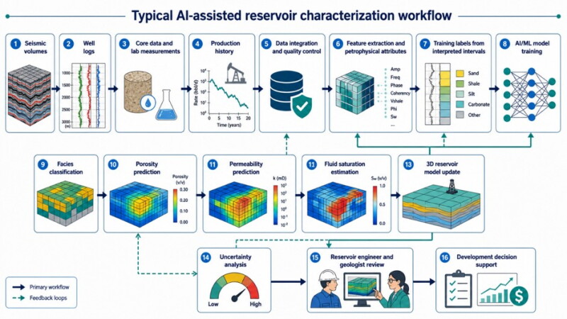
Reservoir Characterization
Exploration success is not only about finding hydrocarbons; it is also about understanding whether the discovered rock can flow, how continuous the pay may be, and where the most attractive development zones lie. AI contributes here by integrating seismic attributes, well logs, core measurements, interpreted intervals, and dynamic data to estimate lithology, porosity, permeability, saturation, and facies distributions between wells.
This reservoir characterization role matters because early development decisions depend on the quality of subsurface models. Better AI-assisted property prediction can sharpen volumetric estimates, reduce uncertainty in sweet-spot mapping, and improve the basis for well placement and development planning. In that sense, AI extends the value of sparse hard data rather than replacing it.
How It Works
The workflow usually starts with hard data from wells, including logs, core plugs, laboratory measurements, and interpreted intervals that provide ground truth for rock and fluid properties. These data are matched with nearby seismic responses and petrophysical attributes so that machine-learning models can learn the relationship between measured reservoir properties and geophysical signatures around them.
After training, the model predicts properties away from the wellbore across the seismic grid, allowing engineers and geoscientists to build denser 3D reservoir-property models than sparse well control alone would allow. Those predictions are then checked against geological understanding and uncertainty ranges, and the model is updated as new wells or revised interpretations become available.
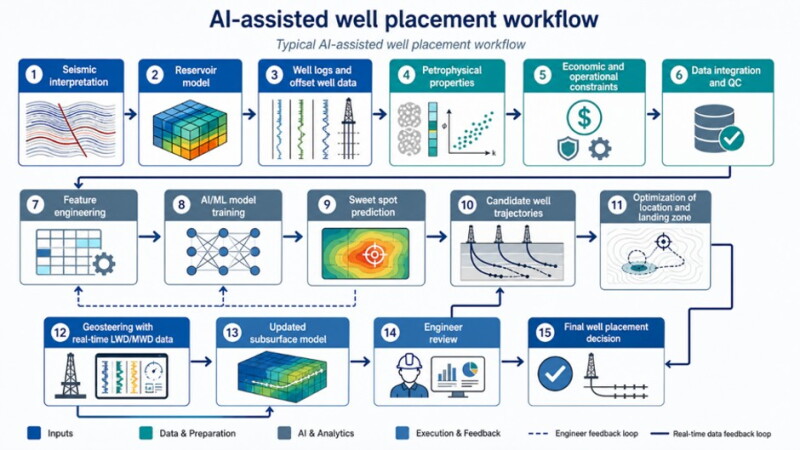
Well Placement and Drilling Optimization
The same AI logic continues into field execution. Once a prospect matures into a drilling candidate, models can evaluate candidate well trajectories by combining structural interpretation, reservoir-quality prediction, offset-well performance, and operational constraints to target the most-productive landing zones.
This shift is significant because the modern drilling workflow is no longer only descriptive. AI is moving beyond dashboards toward systems that generate integrated recommendations across subsurface and drilling domains, with human approvals, audit trails, and operating limits built into the workflow. For exploration teams, that means the line between interpretation and execution is becoming more digitally connected.
How It Works
A well-placement model typically starts with the structural framework, reservoir-property maps, offset-well results, petrophysical indicators, and development constraints such as cost, spacing, hazards, and drilling limits. AI then evaluates candidate locations and trajectories to estimate which path is most likely to maximize net pay exposure, reservoir contact, or economic value while staying within operational limits.
During drilling, the workflow can become dynamic. Real-time LWD and MWD measurements are compared with the predrill model so the AI-assisted system can update the interpreted subsurface position and recommend trajectory adjustments to keep the well inside the target interval (Alcala et al.). Engineers still review these recommendations, but AI shortens the cycle between new data arriving and a steering decision being made.
What Still Limits Performance
Despite the momentum, AI in exploration is constrained by familiar issues: uneven data quality, inconsistent labeling, siloed software environments, sparse training examples for frontier basins, and the difficulty of validating models outside the conditions on which they were trained. The Geophysics survey highlights two especially important technical limits for deep learning in exploration seismology: out-of-distribution generalization and interpretability.
Those limits explain why human expertise remains central. AI can detect patterns, but geoscientists still decide whether those patterns make geologic sense, whether a signal is likely to be healthy under uncertainty, and whether a prospect deserves capital. The winning workflow is, therefore, iterative: experts label, models learn, results are reviewed, uncertainty is assessed, and the loop repeats until confidence improves enough to support a decision.
The Next Phase
The next phase of AI in exploration is likely to be less about isolated models and more integrated technical workflows. Recent industry discussions point toward AI becoming part of the operational fabric of upstream work, where data quality, metadata discipline, machine readability, and human-in-the-loop governance matter as much as model accuracy itself.
The most useful way to frame AI is not as a replacement for geoscience or petroleum engineering but as a new computational layer for subsurface reasoning. Its value is higher when it shortens interpretation cycles, exposes patterns hidden in large data sets, quantifies uncertainty more explicitly, and helps multidisciplinary teams make better exploration and drilling decisions with the data already in hand.

Abdulmalik Ajibade is a reservoir engineer at Beicip-Franlab, France, specializing in digital transformation and AI applications for subsurface and production assets. Ajibade is a certified data analyst and volunteers as a machine-learning engineer at Omdena. He was the winner of the SPE Nigeria Paper Contest for his work on improving production optimization with machine learning. His work focuses on integrating data-driven and AI workflows to enhance asset performance and decision-making in the energy sector.
He holds an MSc in geo-data management for the energy mix from IFP School, France, and a BSc in petroleum and gas engineering from Nile University of Nigeria.

Piergiuseppe Fiore is a reservoir engineer at Eni. He is part of the reservoir management department, working on integrated asset modeling. Previously, he worked on injectivity issues, improved oil recovery, and CCS. He has also specialized in CFD simulations, publishing several articles. Fiore is an active member of SPE and he is the YP chairperson of the SPE Italian Section. He holds an MSc degree in chemical engineering from the University of Calabria and a second-level master’s in petroleum engineering from Polytechnic of Turin.