Is it a bird? Or a bat?
The presence of either can affect offshore wind farm operations, so knowing which aerial wildlife species call the area home or just pass through it helps inform the development of a safe wind energy project that minimizes impacts on birds and bats.
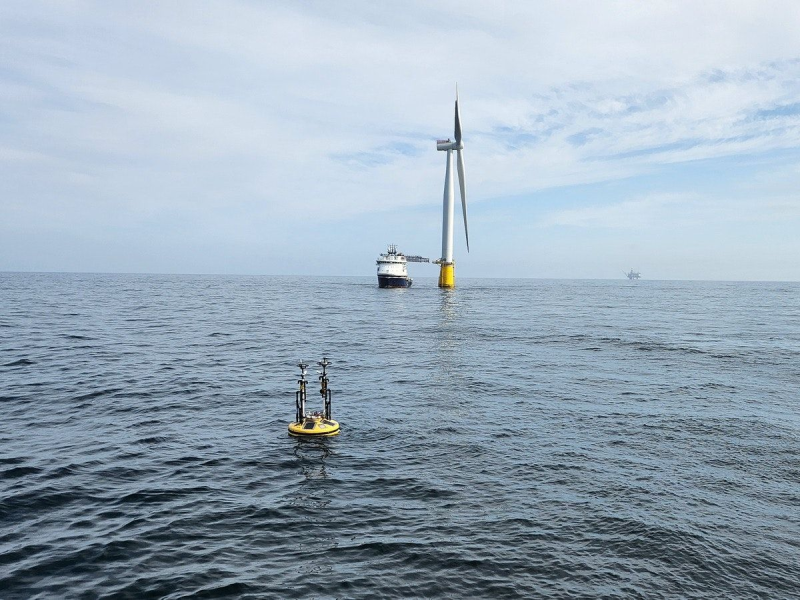
Humans and cameras on vessels or airplanes have traditionally carried out offshore bird surveys, but a new solution puts cameras on buoys to collect comprehensive data and then uses artificial intelligence (AI) to analyze the data.
Equinor piloted the solution in the Norwegian North Sea in 2023.
Earlier this year, Fugro and software company Spoor signed a memorandum of understanding to further develop their bird-monitoring solution, which project developers can use to inform environmental impacts assessments and design collision-risk mitigation strategies for offshore wind projects.

Christian Rasmussen, vice president for partner sales at Spoor, said buoy-based camera surveys of bird and bat activity at potential wind farm sites can provide more accurate information about their presence and behavior in the area, helping to assess a project’s potential impact and reduce associated risks.
“There have been projects that have either over- or underestimated the bird impact,” which could cause delays and, potentially, loss of production. Over- or underestimating bird impact in an area is less likely with a more complete data set, such as that generated by the terabytes of data gathered during a camera-buoy combination’s on-site 12-month deployment, he said.
The camera/buoy combination Fugro and Spoor offer can provide information about bird species, bird abundance, and flight heights and directions at the site. Having proper estimates of bird impacts can help frame decisions about mitigation measures, he said, comparing the data to a form of insurance.
“The potential cost of not doing this right or having enough data can be quite substantial, especially in offshore settings where you might experience delays or have to change the turbine layout, the height of the turbines, and maybe decrease the number of planned turbines,” he said. “We’ve seen that happen due to gaps in bird data.”
He said evolving mitigation measures, such as shutdown on demand as certain birds approach or curtailing turbine operations in certain wind speed ranges to minimize risk to bats, make it more important than ever to have solid data.
Felix Kelberlau, Fugro’s floating LIDAR product lead, said the data gathered by the camera/buoy combination can help a developer reduce uncertainty about a project’s viability. Developers typically need to deploy a buoy during a project’s preconstruction phase to gather metocean data, so adding the bird surveillance scope increases the base cost minimally when compared with gathering bird-monitoring data via vessel or airplane, he said.

Vessel- and airplane-based surveys can yield a paucity of data because of the length and frequency of deployment. Alternatively, radar monitoring can detect birds and it’s not limited to daytime operations as visual surveys are, he said.
The downsides of radar monitoring are that it cannot identify the species of birds that are detected and it’s power-hungry, which is problematic for energy-autonomous operation on buoys.
A buoy-deployed camera can capture usable video during the daytime when fog isn’t present, amounting to nearly 4,500 hours of video per year. Because the camera/buoy combination can be deployed 200 or more miles offshore, a daily health check, which consists of a snapshot or video segment being sent back to shore via 5G network or satellite telemetry, confirms the camera is operational.

Small buoys tend to move a lot in the sea, so one of the challenges Spoor had to address was motion compensation—to stabilize the horizon so that the resulting video footage appeared as if it had been captured from a stable platform, despite operating in wave heights from 10 to 12 m.
Another challenge Spoor addressed was tuning an algorithm to determine whether a bird that left the frame and was later detected again was the same individual or a different one.
The marine-grade camera was tested under various conditions to evaluate image quality, field of view, and zoom capabilities. It features adequate data storage and is compatible with the power supply provided by the buoy.
While placing four cameras on a buoy would provide 360-degree coverage, Kelberlau described using two cameras as “a good compromise” because this setup would always have at least one camera pointed in the right direction.
“You don’t want to film towards the sun, right? Because, towards the sun, you just have a black dot as a bird, and you will not be able to recognize what kind of bird it is unless you can analyze the flight path. So, you always get nicer footage from the camera when it’s not facing the sun,” he said.
Working Together
Fugro provides the buoy under the company’s SEAWATCH brand. The buoys are deployed at offshore sites continuously for 6 to 12 months to gather oceanographic and meteorological data. The LIDAR buoys also measure wind speeds at the buoy and at elevated heights—data that is crucial for wind farm development. Additionally, Fugro has also been equipping its buoys with acoustic recorders and cameras to detect bats, birds, and marine mammals.
Rasmussen said that, several years ago, Spoor identified the need for better data to support offshore wind projects and saw a camera-based bird-monitoring system—deployable throughout a wind project’s life cycle—as a breakthrough solution.
“We saw the gap in data compared to today’s methods of collecting bird data,” he said, noting it made sense to Spoor to “piggyback on Fugro’s already existing expertise and platform.”
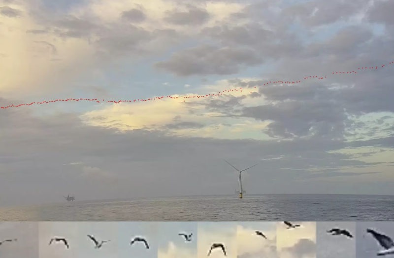
Spoor’s AI software can detect and track any bird that appears in the video footage for more than one second. The video output is combined with imagery of the bird’s flight trajectory—whether solitary or part of a flock—and the solution then delivers statistics on temporal distribution, flight height, species, and abundance, all correlated with wind speed and direction.
“We get, of course, many, many, many terabytes of data that we have to process,” which involves filtering out non-bird events, manual labeling of bird events, quality assurance, and training the algorithm to automatically detect and identify the species, Rasmussen said.
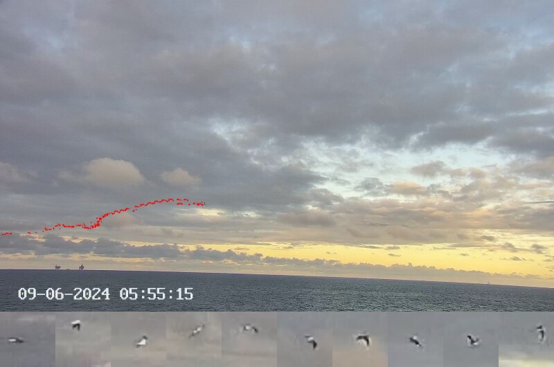
Each bird event comes with data including the timestamp, flight height, and main flight direction. The data is aggregated in Spoor’s platform and can be used for reporting, enabling environmental consultants to draw conclusions based on the findings.
“What we would like to stick to, if we talk roles, is that we are a data provider. We process the data, and we let the environmental consultancy base their conclusions on our data and work with our data. And that's simply us making sure that we stick to being a software and data provider,” he said.
Pilot Project
Spoor and Fugro started collaborating in 2021 to develop the solution, with camera testing following in 2022 and 2023. The solution was piloted at Equinor’s Hywind Tampen Floating Wind Farm from 10 June to 14 October 2023.
A control system enabled the activation and deactivation of the camera equipment, with data capture programmed for specific times during daylight hours to avoid unnecessary storage of footage captured in darkness.
Video footage from the Equinor deployment was recorded on six 8-TB solid-state drives, which were collected for analysis after the deployment ended. The four deployed cameras detected a total of 55,868 birds and captured 52.1 hours of unique bird activity, with 4,880 hours of video footage analyzed.
Although the Equinor deployment showed promise, widespread acceptance of the solution may take some time.
“The obstacles we face aren’t technological anymore; those challenges are solved. This system is market ready. The challenge is more the legislation for the certification of wind farms” that requires environmental monitoring and environmental impact assessment, Kelberlau said, noting such requirements vary by location.
Because the buoy-based camera solution has not yet received many regulatory stamps of approval for environmental monitoring, it can be tough to get buy-in for the method.
“It’s a bit of a chicken-and-egg problem,” he said. “As long as it’s not widely accepted, we don’t really get the chance to prove that it is good, and without proving that it is good, it won’t get widely accepted.”
Rasmussen said the companies are working with regulators to earn approval for the buoy-based camera in environmental monitoring. “Regulators also start picking up on new technologies, and I think those are acknowledging that they have to accept new methods and technologies simply to get this type of data,” he said.
At least one third-party organization—The Biodiversity Consultancy—has reviewed the approach and concluded that, while the spatial coverage may be limited, buoy-based cameras otherwise “provide a good balance of temporal coverage, accuracy, and flight-height estimation (to inform collision risk), whilst maintaining cost efficiency. As such, buoy-mounted cameras are likely to be a worthwhile complementary survey method to traditional approaches, such as vessel, or digital aerial surveys, which offer better spatial coverage, but are more limited in the temporal coverage that they can achieve,” the organization said on its website.
While Fugro and Spoor work through the solution’s chicken-and-egg phase, they are in “close dialogue” for deployments with potential customers, Rasmussen said.
“We have quite a proper pipeline of projects that we’re working on right now,” he said.