
Planning, developing, and tracking oil and gas projects has become increasingly costly. And, with a shrinking workforce, energy companies in every stream—up, mid, and down—are adopting new technology to create efficiencies that empower the staff they do have to accomplish more and accelerate the schedule.
In-person collecting and assembling of data over the great distances involved in these projects could require months of intensive compilation and distillation. It would also demand large capital outlays for wages, travel, lodging, and other expenses. Some estimates show that a survey team on a pipeline route can cover only about 8 miles per day.
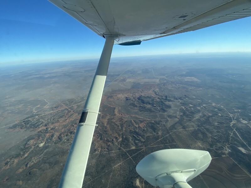
The idea of using aerial photography to replace foot traffic, and to provide otherwise impossible overviews, predates human flight, with balloons and kites used to lift cameras in its earliest iterations. Today’s technology uses lenses to gather fine detail and otherwise invisible light spectra never before available.
Now, a single fixed-wing flyover can cover hundreds of miles in a few hours, slashing costs and reducing gathering time significantly. Depending on what information is needed, aerial imagery can accomplish a wide variety of tasks, such as counting fences, identifying vegetation, plotting elevations, and tracking methane emissions. It can deliver that data, in most cases, in as little as 2 weeks. Data collection and processing for larger areas may take longer, and all delivery timetables, regardless of project size, are dependent on clear weather.
Because the data is available in a variety of formats that can be placed on the cloud or delivered through email, firms with interests across states or oceans use aerial imagery to keep everyone in the loop wherever they are.
Top Aerial Imagery Efficiencies
Site Selection and Exploration. Aerial photography provides a comprehensive overview of the landscape and enables planners to assess potential sites for further investigation. High-resolution aerial images allow for detailed analysis of terrain, vegetation, and geological features.
Planning and Design. By capturing detailed images of the landscape, including existing infrastructure, water bodies, and nearby communities, aerial surveys help in determining the optimal locations for drilling pads, pipelines, access roads, tank batteries, and other facilities. This information aids in minimizing environmental impact and maximizing operational efficiency.
Environmental Impact Assessment. Upstream and midstream operations require thorough environmental impact assessments to ensure compliance with regulations and minimal ecological disturbances. Aerial photography allows for accurate and up-to-date documentation of pre- and post-operation conditions. By capturing images of the surrounding environment, such as wetlands, forests, and wildlife habitats, companies can assess potential impacts and develop mitigation strategies accordingly.
Pipeline Planning and Monitoring. Aerial photography helps in pipeline planning by providing detailed images of the terrain, identifying potential obstacles, and determining the optimal route. During construction and maintenance, aerial surveys enable ongoing monitoring of pipeline integrity, detecting leaks, encroachments, or other issues that may require attention.
The Department of Transportation’s Pipeline Hazardous Materials Safety Administration (PHMSA) sets safety standards for pipelines transporting hazardous materials based on the type and kind of civilization through which it travels. In spring of 2022, the agency’s Mega Rule expanded the number of locations it designates as high-consequence areas versus medium-consequence areas. That means operators need an efficient way to reevaluate every mile of pipe, especially in or near populated areas. High-consequence areas require pipelines to use a higher grade of pipe to better protect surrounding populations from possible leaks.
With most urban areas continuing to expand, monitoring regularly for any new encroachment has been important, and the Mega Rule raises the bar even further. Aerial photography can quickly inform these decisions.
Even better, regular monitoring during the planning and open season stages can help planners observe trends to predict what areas will need higher-grade pipe in the future. Otherwise, they might have to spend millions digging up and replacing significant pipe sections.
Safety and Security. Aerial surveillance also can aid in emergency-response planning, facilitating efficient coordination and resource allocation during critical situations.
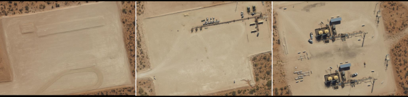
Asset Monitoring and Change Management. Regular aerial surveys can track changes in infrastructure, such as well pads, storage tanks, and processing facilities, allowing for proactive maintenance and optimization (Fig. 1). Additionally, aerial images provide valuable data for asset valuation and documentation purposes.
For change detection, a geographic information system (GIS) highlights any ways a new image differs from the last one.
Environmental Protection Agency (EPA) Compliance. With state and federal agencies (including the EPA) all ramping up requirements for detecting and remediating leaks of methane and other hazardous substances, regular aerial surveys are going to be vital in expediting compliance. And because every cubic foot of methane leaked is a cubic foot not sold, leak remediation benefits the industry as well. A specially designed light detection and ranging (LiDAR) camera usually is used for this purpose.
Types of Aerial Imagery and Their Uses
Depending on the end use, several types of aerial imagery and aerial remote sensing options are available.
GIS. Using GIS technology allows the provider to pinpoint the location of every feature in the image in relation to its position to other objects. This is useful for determining encroachment, assessing the right spacing for new structures, and determining geographic features such as drainage patterns.
Geometrically corrected orthoimagery, while rich in detail and broad in vision, is simple to use out of the box. It requires no GIS training or IT involvement. End users can use the data immediately if they have basic GIS or computer-aided design software. In most cases, imagery also can be provided through a web-based map viewer or streamed into Google Earth.
RGB Orthoimagery. Red, green, blue (RGB) indicates the visible spectrum, the three basic colors in a TV or computer screen. In this case, RGB orthoimagery captures multiple views of the terrain in that range during daylight hours. A process called orthorectification removes all distortions. The end product is a geometrically accurate base map of the area of interest, which allows users to determine the measurements needed to complete a wide range of calculations.
The resolution of the photos can be set to fine or wide, depending on the end use. If the survey is just for large items, a lower resolution (15 cm) may be plenty. If finer detail is needed, the resolution can be set as high as 2.5 cm.
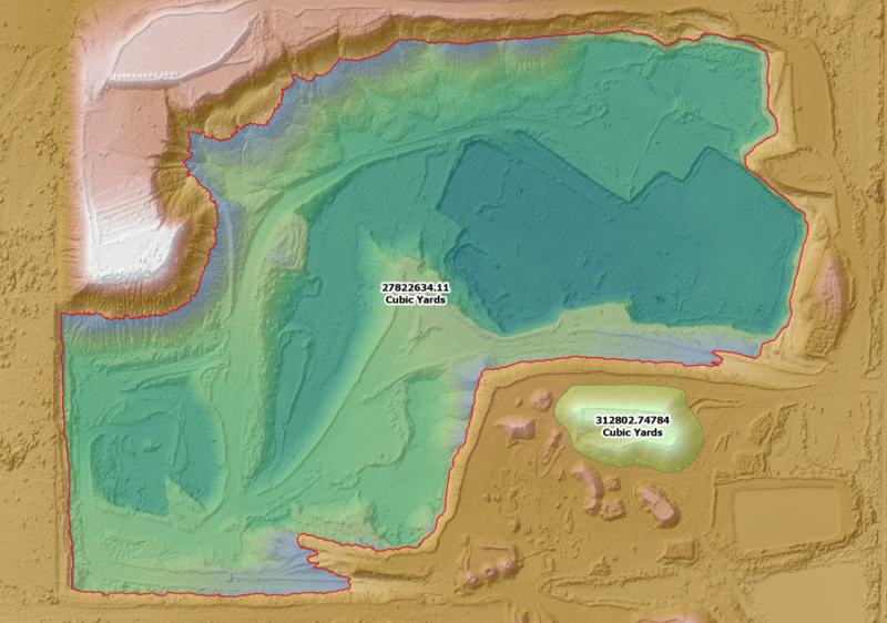
RBG orthoimagery can be processed further using photogrammetry (Fig. 2). Photogrammetry uses triangulation to compare multiple images, analyzing them for precise location and elevation. It helps end users identify ground objects and determine their height and precise relative locations. The resulting digital surface models and digital elevation models offer a precise and detailed understanding of the terrain.
RBG orthoimagery is used to identify large features such as infrastructure or buildings (lower resolution, 10 cm) and model terrain such as stream networks and drainage patterns, contour lines, and slope (higher resolution, up to 2.5 cm).
More specifically, the technique can be used to identify and plan drilling locations, assessing access options and proximity to infrastructure and possible regulatory issues; plan and organize large sites for facilities or pads; monitor progress of construction inside and possible encroachment from outside; and plan spill response and proximity to environmental hazards.
Four-Band Imagery (Multispectral). Four-band imagery adds near-infrared images to RGB. Infrared light can be detected by nocturnal animals naturally and by humans with the help of night-vision viewers. Near-infrared light waves are just below the human-visible range.
It helps in evaluating crops because healthy plants show up as bright red in this spectrum instead of the greens visible to the human eye. It also reveals plant stresses such as insect damage, poor soil, or too much/too little soil moisture. Multispectral imagery can be used to identify surface water boundaries, road surface quality, soil erosion, and certain subtle topographic variations invisible to RGB or other imagery methods. Mostly used in agriculture, it can also help spot methane leaks in pipelines because those leaks can kill or damage nearby plants.
Thermal Imaging. This process uses specially designed cameras and lenses to detect infrared radiation emitted by objects. From this, visible images of an object’s heat signature are created, which are displayed in a range of temperature-related colors. Colors range from bright/white for warmer temperatures to darker/red for cooler temperatures.
Thermal imaging can be used to detect leaks in oil, water, and gas lines, including methane, and for heat mapping of structures to determine energy loss. Like four-band imagery, it can be used to inspect crop health. It also can be used to detect leak value changes in pipelines and failures in solar panel cells.
LiDAR. An abbreviation for light detection and ranging, LiDAR bounces laser light off objects, measuring the amount of time the light takes to return to the onboard sensor to obtain high-resolution, 3D data in a form known as point clouds.
Because the data is in three dimensions, it gives detailed elevation maps of terrain, vegetation, structures, and more.
Specifically, it is used in midstream for leak detection/spill management, right-of-way compliance, construction monitoring, mapping of vegetation and land cover, and PHMSA compliance.
For upstream, it is used for methane leak detection, site planning and change detection, lease road mapping, and offshore spill detection and response.
A Simple Solution That Speeds the Process
As more companies are digitizing well monitoring/control, invoicing, and other systems, many are also realizing that aerial photography is another tool in that box. It is much faster and more efficient than on-the-ground surveys, and it assimilates and propagates the data across the office and around the world, making the existing workforce more efficient.
