Getting work done in a labor-constrained industry such as energy is challenging on the best of days. On top of normal workloads, ever-tightening regulatory scrutiny grows the to-do list seemingly by the day. Compounding the problem is the fact that energy projects of all sorts cover spaces measured in acres or square miles and are often hundreds of miles away from headquarters. To gather the information needed to plan, build, and monitor these far-reaching projects, companies need either to staff up additional survey crews or to carve out significant time and budget to put decision-makers on the road. More and more companies, though, are empowering existing personnel to work smarter by putting high-value, birds-eye-view visuals at their fingertips.
Advanced aerial imagery—be it collected from drone, satellite, or fixed-wing aircraft—is one of the best options available for securing the critical information needed to run things smoother in the oil field and along rights of way. Better yet, this information is easily accessible whether you are at an industry conference in Denver or huddled with your team at HQ in Houston.
A High-Tech Solution (Zero Technical Expertise Required)
In an old industry such as oil and gas, adopting new technology that replaces traditional boots-on-the-ground intel often feels like it’s more trouble than it’s worth. Fortunately, with advanced aerial imagery—known in the geospatial intelligence world as orthophotography or orthoimagery—the tech magic happens before it hits your desktop.
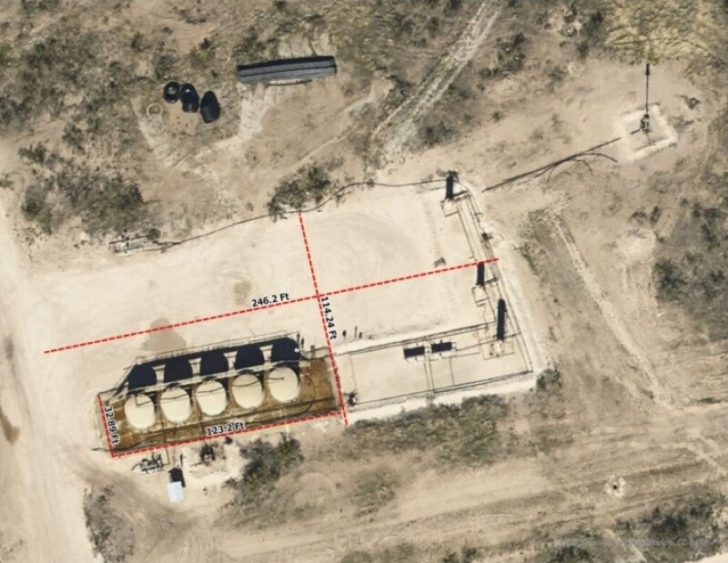
To create effective orthophotography, imagery is taken during peak daylight hours and then is geometrically corrected to remove distortions through a process called orthorectification. Sensor information and digital modeling help inform the geometric elements; the final product is likely the result of analysis of several photographs. The resulting map delivers a precise, time-stamped view of structures and activities across (and, for pipelines, abutting) your area of interest (AOI). The geospatially accurate map also allows you to obtain the highly precise measurements required for a variety of planning, operational, and compliance-related activities (Fig. 1).
Putting the intel to work is as simple as pulling up the maps in a geographic information system (GIS) or computer-aided design software. In most cases, imagery can also be provided through a web-based map viewer or streamed into Google Earth.
Quick Answers at Your Fingertips: Real-Life Examples
Orthophotographic maps are deceptively simple, but, for upstream and midstream professionals, they pack a powerful information punch that can lead to dozens of efficiencies. Owners and operators of all sizes can use the intelligence to plan and operate smarter, avoid budget pitfalls, and get projects finished faster.
One Texas-based exploration and production (E&P) company uses its West Texas imagery to get more done every day across all departments. A few specific uses are assessing access options and proximity to infrastructure to identify optimal pad locations, sketching out infrastructure schemas for future wells, and calculating exactly how much road base is needed for new roads or repairs.
Recently, the company used its imagery to bring a highly complex project to life: the creation of a “mini city” to support the simultaneous completion or workover of approximately 12 wells. In the past, such a project would have triggered a host of 12-hour trips to and from the field for project planning. The company greatly reduced, and in many cases eliminated, the need for face-to-face meetings by putting aerial imagery to work.
The company saw the following advantages:
- In lieu of walkthroughs, vendors were provided with surveys overlaid on the imagery. In addition to reducing the time it took to get the bids, accuracy was increased, which helped avoid delays and costly change orders once operations began.
- Equipment placement was optimized for efficiency and safety; planners were able to zoom in to make highly granular decisions such as where it made the most sense to anchor a workover rig.
- Traffic control vendors were given clear visual expectations for blocking and rerouting traffic, resulting in greater safety.
The company estimates that these planning efficiencies helped shave nearly 2 weeks off their time on-site. In a day-rate-driven industry such as energy, the budget savings were significant—not to mention the quicker revenue gained from a dozen wells coming online faster.
Pipeline owners and operators also benefit from an array of time- and cost-saving advantages, mainly because aerial imagery can help maximize the efficiency of existing personnel, in and out of the field.
For route planning, obstructions or land issues can be identified and assessed in the office and a more informed decision can be made regarding the need to dispatch a ground crew. One Texas-based midstream company uses its imagery to manage landowner concerns. Flyovers of prospective routes are conducted just weeks before the start of a project to capture the exact conditions on the ground. If a landowner raises concerns such as the route running too close to a road, structure, or even where a beloved dog is buried, planners can analyze the lay of the land in real time. They can present compromises to their legal team from the comfort of their desks, then adjust the route accordingly once landowner buy-in is received.
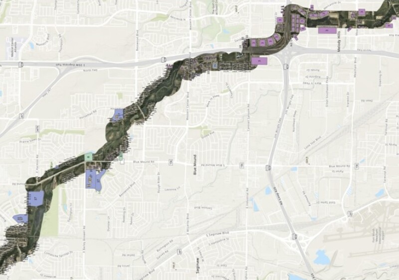
For regulatory compliance, aerial imagery can take pressure off of ground crews. Typically, class location studies require dispatching crews to count structures physically and monitor signs of development. Strategic flyovers provide the visuals needed to identify structures along a right of way from the air—the first data-collection step to identifying US Department of Transportation class location, high-consequence areas, and medium-consequence areas (Fig. 2). Once the structures are identified, the data can be plugged into internal sliding mile calculations. Changes from year to year can be flagged using GIS change detection capabilities, further simplifying efforts. Circling back to initial route planning, visual intelligence gained along potential rights of way can be used to identify population density trends to get a jump on future compliance concerns. With this critical information in hand, decisions regarding the type of pipe needed can be made today, helping avoid costly surprises tomorrow.
Collecting Aerial Imagery: Methods To Consider
Once a decision is made to take to the air for answers, the question becomes how to secure the imagery. For industrial applications, aerial imagery is most useful when it is high-resolution and recently captured. It also must be cost-effective, especially when considering the size and potential remoteness of many energy projects. Keeping these three factors in mind, the following are the options:
- Fixed-wing manned aircraft—Aerial imagery captured by aircraft typically involves one pilot flying a defined AOI. Depending on the size of the area, the flyover can be completed in a single morning or flown over days or weeks to cover the ground required. Regardless, fixed-wing manned aircraft is quick, efficient, and particularly effective for larger-scale projects. Resolution can be set from as fine as 2.5 cm to as large as 15 cm. Clear weather is critical to ensuring the final product’s clarity, so delivery times are always weather-dependent.
- Drones—While drones can capture much of the same data as fixed-wing aircraft, the former are generally limited to the pilot’s line of sight. In other words, the operator must be able to see the drone when it is in the air. This is beginning to change, but a drone is still limited to a few miles in range. Dozens of drone flights, potentially with multiple operators over several days, would be necessary to gather the same data a fixed-wing flight can get in one fell swoop for a larger project. This manpower-intensive approach comes with a manpower-intensive price tag; it is not a cost-effective option for capturing information on larger AOIs. One thing to note, however, is that fixed-wing aerial efforts can work hand in hand with drone efforts, capturing large swaths of data while helping pinpoint areas that could benefit from further drone inspection.
- Satellites—Satellites solve the size-of-AOI issue but can have timing and image detail/accuracy drawbacks. General services such as Google Earth say they are updated daily, and that is true; some updates are done every day, in small increments. But the entire database is only covered every few years, meaning a site needed by an E&P or midstream planner could be up to 5 years out of date. The Sentinel-2 satellite collects imagery of the whole Earth every day or two, but its data is collected at 10 m. You can get quick updates, but the resolution is extremely low. The most readily available custom satellite data imagery is collected at 30 cm but is then converted to 15 cm. Orthorectification, which removes any distortion of the imagery, may not be available. Google Earth does this, but others may not.
The Advanced Aerial Imagery Advantages Are Clear
Advanced aerial imagery is revolutionizing the energy industry by providing high-value, geospatially accurate visual intelligence. With labor constraints and regulatory scrutiny making work more difficult, companies need to empower their personnel with advanced technology to gather the information needed for planning, building, and monitoring projects. Orthophotography provides precise, time-stamped views of structures and activities, allowing for a near-real-time bird’s-eye view of critical, faraway AOIs. With orthophotography, companies can operate smarter, avoid budget pitfalls, and get projects finished faster. With these benefits, it’s clear that advanced aerial imagery can play a big part in the future of the energy industry.