
NASA’s Earth Surface Mineral Dust Source Investigation (EMIT) mission is mapping the prevalence of key minerals in the planet’s dust-producing deserts—information that will advance our understanding of airborne dust’s effects on climate. But EMIT has demonstrated another crucial capability: detecting the presence of methane, a potent greenhouse gas.
In the data EMIT has collected since being installed on the International Space Station in July, the science team has identified more than 50 super-emitters in Central Asia, the Middle East, and the Southwestern United States. Super-emitters are facilities, equipment, and other infrastructure, typically in the fossil-fuel, waste, or agriculture sectors, that emit methane at high rates.
“Reining in methane emissions is key to limiting global warming. This exciting new development will not only help researchers better pinpoint where methane leaks are coming from but also provide insight on how they can be addressed—quickly,” said NASA Administrator Bill Nelson. “The International Space Station and NASA’s more than two dozen satellites and instruments in space have long been invaluable in determining changes to the Earth’s climate. EMIT is proving to be a critical tool in our toolbox to measure this potent greenhouse gas—and stop it at the source.”
Methane absorbs infrared light in a unique pattern—called a spectral fingerprint—that EMIT’s imaging spectrometer can discern with high accuracy and precision. The instrument can also measure carbon dioxide.
The new observations stem from the broad coverage of the planet afforded by the space station’s orbit, as well as from EMIT’s ability to scan swaths of Earth’s surface dozens of miles wide while resolving areas as small as a soccer field.
“These results are exceptional, and they demonstrate the value of pairing global-scale perspective with the resolution required to identify methane point sources, down to the facility scale,” said David Thompson, EMIT’s instrument scientist and a senior research scientist at NASA’s Jet Propulsion Laboratory in Southern California, which manages the mission. “It’s a unique capability that will raise the bar on efforts to attribute methane sources and mitigate emissions from human activities.”
Relative to carbon dioxide, methane makes up a fraction of human-caused greenhouse-gas emissions, but it’s estimated to be 80 times more effective, ton for ton, at trapping heat in the atmosphere in the 20 years after release. Moreover, where carbon dioxide lingers for centuries, methane persists for about a decade, meaning that, if emissions are reduced, the atmosphere will respond in a similar timeframe, leading to slower near-term warming.
Identifying methane point sources can be a key step in the process. With knowledge of the locations of big emitters, operators of facilities, equipment, and infrastructure giving off the gas can quickly act to limit emissions.
EMIT’s methane observations came as scientists verified the accuracy of the imaging spectrometer’s mineral data. Over its mission, EMIT will collect measurements of surface minerals in arid regions of Africa, Asia, North and South America, and Australia. The data will help researchers better understand airborne dust particles’ role in heating and cooling Earth’s atmosphere and surface.
“We have been eager to see how EMIT’s mineral data will improve climate modeling,” said Kate Calvin, NASA’s chief scientist and senior climate advisor. “This additional methane-detecting capability offers a remarkable opportunity to measure and monitor greenhouse gases that contribute to climate change.”
Detecting Methane Plumes
The mission’s study area coincides with known methane hotspots around the world, enabling researchers to look for the gas in those regions to test the capability of the imaging spectrometer.
“Some of the plumes EMIT detected are among the largest ever seen—unlike anything that has ever been observed from space,” said Andrew Thorpe, a research technologist at JPL leading the EMIT methane effort. “What we’ve found in a just a short time already exceeds our expectations.”
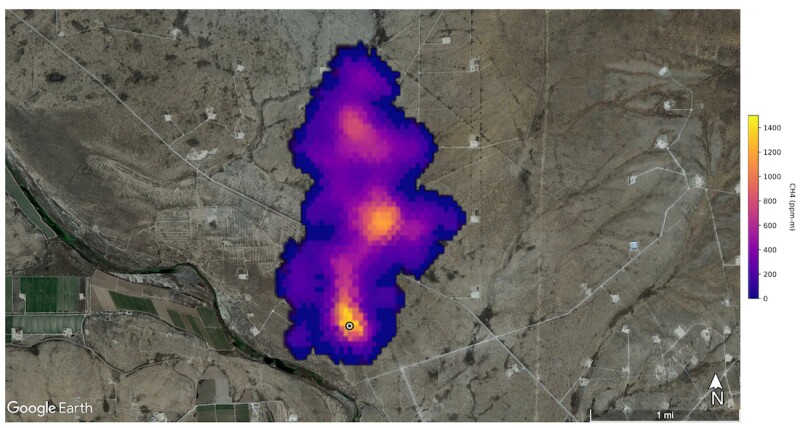
For example, the instrument detected a plume about 2 miles long southeast of Carlsbad, New Mexico, in the Permian Basin. One of the largest oil fields in the world, the Permian spans parts of southeastern New Mexico and western Texas.
In Turkmenistan, EMIT identified 12 plumes from oil and gas infrastructure east of the Caspian Sea port city of Hazar. Blowing to the west, some plumes stretch more than 20 miles.
The team also identified a methane plume south of Tehran, Iran, at least 3 miles long, from a major waste-processing complex. Methane is a byproduct of decomposition, and landfills can be a major source.
Scientists estimate flow rates of about 18,300 kg/h at the Permian site, 50,400 kg/h in total for the Turkmenistan sources, and 8,500 kg/h at the Iran site.
The Turkmenistan sources together have a similar flow rate to the 2015 Aliso Canyon gas leak, which exceeded 50,000 kg/h at times. The Los Angeles-area disaster was among the largest methane releases in US history.
With wide, repeated coverage from its vantage point on the space station, EMIT will potentially find hundreds of super-emitters—some of them previously spotted through air-, space-, or ground-based measurement and others that were unknown.
“As it continues to survey the planet, EMIT will observe places in which no one thought to look for greenhouse-gas emitters before, and it will find plumes that no one expects,” said Robert Green, EMIT’s principal investigator at JPL.