Reservoir

The technology has passed its first phase of qualification, with 84 nodes placed on the seafloor at a depth of 2,000 m to acquire 4D seismic data in the pre-salt Santos Basin.

Chevron and Halliburton describe how they built and deployed the fully autonomous closed-loop fracturing system that enables subsurface-driven optimization.

This article from the SPE Integrated Reservoir Management Technical Section (IRMTS) addresses decision timing across the reservoir cycle.
-
 This paper presents a numerical simulation work flow, with emphasis on hydraulic fracture simulation, that optimizes well spacing and completion design simultaneously.
 -
Recent studies have reignited the question of whether US oil and gas companies are ignoring the opportunity to refracture large swaths of maturing assets.
-
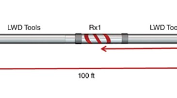
This paper describes the deployment of an ultradeep electromagnetic directional-resistivity instrument to map injection-water movement.
-
The authors discuss the development of a deep-learning model to identify errors in simulation-based performance prediction in unconventional reservoirs.
-
The authors of this paper compare case studies from the Bakken and the STACK plays to conclude that mineralogy, petrophysics, and reservoir-condition differences between basins cause differences in the effect of fracture-driven interactions.
-
This paper shares details of 2 years of monitoring the first commingled updip smart water injector drilled in the Piltun area of the Piltun-Astokhskoye offshore oil and gas field.
-
In this second part of a two-part series on advances in artificial lift, we’ll look at the state of optimization and a trio of techniques and technologies under development or new to the market. Look for quarterly reviews of specific types of lift in upcoming issues in the new year.
-
This paper describes a high-density high-pressure/high-temperature brine-based drilling fluid that provides long-term stability and solids-suspension properties for extended periods of time.
-
Understanding the injected-water preferential paths is a key aspect of waterflood optimization in reservoirs characterized by strong vertical and areal heterogeneities. Devising specific work flows for such applications is important.
-
This paper discusses a waterflood optimization system that provides monitoring and surveillance dashboards with artificial-intelligence and machine-learning components to generate and assess insights into waterflood operational efficiency.